A pretty monumental day in my very young teaching career, as tried my first ever activity that I had created.
We are beginning our unit on Early Civilization, and I wanted to make sure the students fully understood the birthplace of man, and the evolution and migration of man as he developed into present day modern man.
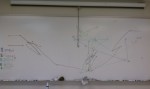
The students were broken into 5 groups, and each group was given a list of coordinates. The students were instructed they were Archaeologists, and they must locate and plot the locations of these fossil sites. They were given individual maps, and as they plotted their groups locations, one member of the group would plot the locations on a larger class map that I projected on the white board. The white board map allowed me to show the full migration pattern to the entire class.
After the students plotted the points, they began to work on discussion questions that allowed them to think critically on the data they had created. There are no right or wrong answers, but instead, the students could present theories and give evidence for what they saw.
Here are some pictures of the board after class ended, and I have included the handouts I used below as well.